Top 5 Navigation Apps other than Google Maps
Top 5 Alternatives to Google Maps: Maps & Navigation Apps
With a smartphone and Google Maps integrated with it, going round in circles on a stranded island would be such a cliché, when you can just take out your smartphone, get a boat and go home. Just kidding! Using a navigation app, you can do so much more, like book a cab, find points of interest, get nearby restaurants and much more. But did you think Google Maps is the only mobile app that’s good for navigation? Well, that is apparently not true, because mobile app development scenarios have come far beyond depending on single solutions.
Although not many know about mobile apps built for navigation other than Google Maps; in no way are other navigation apps inferior. However, mobile app developers, through these navigation apps, have tried to focus on solving specific problems, which Google Maps fails at.
5 Best Google Maps Alternatives and Similar Navigation Apps
Ready to see something new? Here goes the list:
Waze
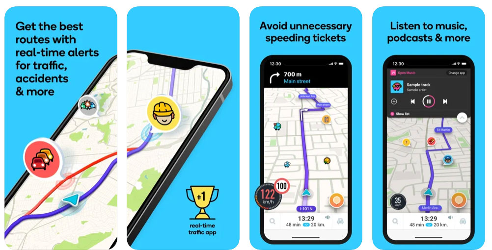
When it comes to real-time navigation, Waze clearly distinguishes itself from others by providing much more information than Google Maps. All you have to do is select your start and end destination, and the app would figure out the best paths and routes to get you there. Waze uses an exclusive network of its own, which keeps a track of real-time traffic situations and route availability.
Other Waze users can alert the network regarding traffic jams or broken route, and in response, Waze network will optimize the route for other users on the network. Additionally, one can also find restaurants, gas stations, shopping malls, public transport, cab services and much more on Waze, which also comes with a Google Maps and Foursquare integration.
Basic GPS navigation app’s features are:
- Carpool services;
- Useful adds-on (social network integrations);
- Drive planning;
- Real-time updates and notifications;
- Voice instructions.
The basic essentials of the app are:
- Geolocation;
- Voice recognition system;
- Social elements;
- Bright, intuitive design.
Why Waze?
◦ See what’s happening – Alerts about traffic, police, hazards and more on your drive
◦ Speedometer – Get an alert when you reach the speed limit to help you avoid tickets & drive safer.
◦ Get there faster – Instant routing changes to avoid traffic and save you time
◦ Toll costs – Waze keeps you in-the-know about toll charges on your route.
◦ Know when you’ll arrive – Your ETA is based on live traffic data
◦ Pay less for gas – Find the cheapest gas along your route
◦ Play music & more – Listen to your favorite apps for music, podcasts & more right from Waze
◦ Drive with Android Auto – Use Waze on your car’s display
◦ Always find the way – Choose from a variety of voices to guide you while you drive
Tom Tom
TomTom maps and traffic data open up a new world for millions of HUAWEI users and developers
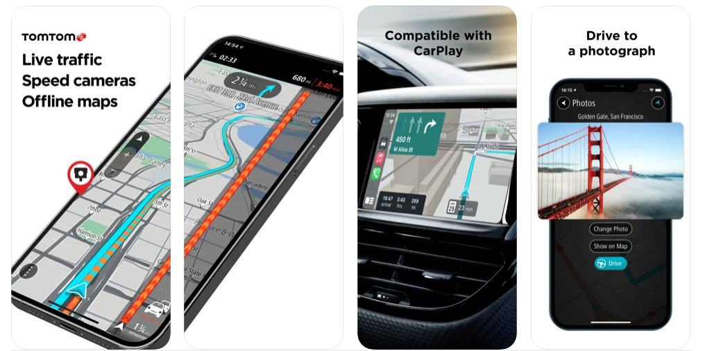
Tom Tom allows you to dodge traffic police and speed cameras by alerting you well in advance. But let’s just not treat this feature as USP of this app. Apart from helping drivers in a hurry, Tom Tom also allows a person to navigate offline. That means, you can download the map of a particular area for free, and use it without internet connection, anywhere, anytime.
And it is not always that app development companies build an app like Tom Tom that gives you a clear idea of lanes, which is often confusing whilst on a highway. Another thing we liked about Tom Tom is that it allows users to search anything quickly, with ‘Quick Search’, which starts suggesting destination names as you type.
Also Read: How Much Does it Cost to Develop Mobile Wallet App like PayTM
Map Factor
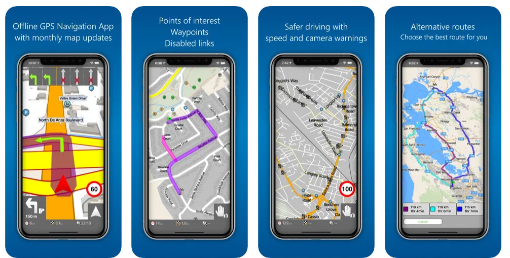
With over 30 million downloads on Google Play Store, Map Factor is an optimum navigation solution in all terms. Allowing door-to-door route planning, this app is pretty accurate in its purpose. Its unique interface and user-friendly design have been keeping it among top navigation apps on Play Store. And the unique navigation interface it has, comes from OpenStreetMap, which is an open-source map by Wikipedia.
When you download the app, MapFactor allows you to choose from free basic navigation or paid advanced navigation features. Some of the other navigations features the app offers are 2D and 3D navigation modes, personalization options, voice navigation etc.
Also Read: How Much Does It Cost to Make an App?
Key features of the MapFactor GPS Navigation app:
- – voice navigation in various languages
- – door-to-door route planning
- – overview of the upcoming manoeuvre and distance shown on the screen
- – free offline maps with postcodes (full GB postcodes) installed on your device
- – points of interest
- – speed limit and camera warnings
- – favourite routes and places
- – 2D/3D mode allows realistic visual maps display
- – day/night map mode
- – routing modes for car, bus, pedestrian, bicycle, motocycle
- – route avoidance – block certain road from your route
- – maps rotate in driving direction, or north up
Maps.me
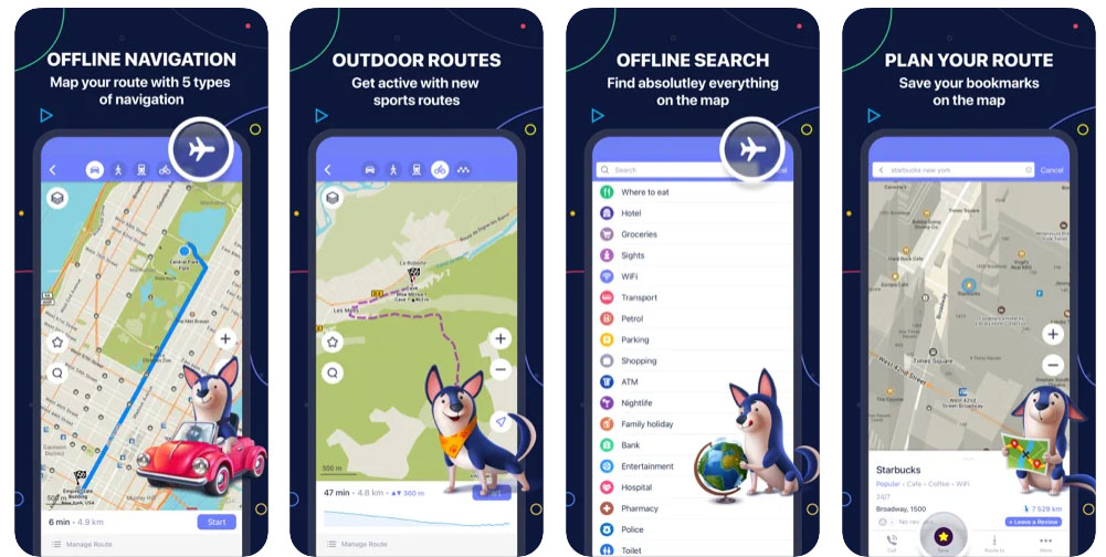
Another great solution for trips and casual stays, Maps.me is a full-fledged offline navigation app that, along with navigation, brings up a list of hotels to choose from. What makes this app no less than a jewel, is that it lets a user find point of interests, as well as interesting activities like adventure sports. Other than that, the usual trending features it has, are traffic alerts, location bookmarks, location sharing; all for free.
Features:
- Offline maps
- Navigation
- Travel guides
- Incredibly detailed
- Up-to-date
- Fast and reliable
- Bookmarks
Sygic
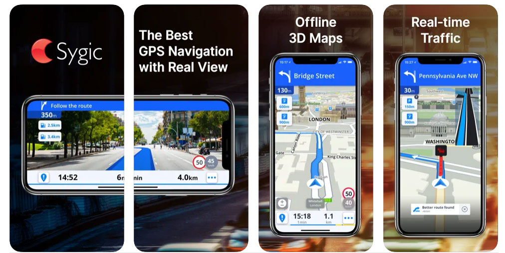
Sygic is one of those few apps that have achieved Augmented Reality Integration. As a result, Sygic feels more advanced compared to any other navigations apps. The AR integration has been tuned to assist in turn-by-turn navigation and broken routes.
Taking navigation to another level, Sygic allows you to find parking spaces, use offline navigation, cheap gas stations and do much more than just finding routes. Just like any other navigation app, Sygic also gives you real-time traffic updates, but what separates it from rest of the lot is its ability to identify street names, input via voice. For safety, you can find Heads-up Display which shows up according to time of the day. Dynamic Lane Guidance and Junction View for safe lane changes have also been included in the app.
So these were some of the navigation apps that you could use if you are tired of using Google Maps or, just in case, looking for a change. In some of these apps, applications of Artificial Intelligence can also be seen, which is paving the way for an automated tomorrow, comprising of self-driving cars, machine learning automation and full-fledged IoT integration.
Its all about Top 5 navigation apps for traveling abroad
Want to Develop Similar App like this?
Get A Quote For The Custom Features You Want
Have a plan to develop a mobile navigation apps? If you do, you are at right place. We at SMACware, a mobile app development company, are here to help you launch high security & superior quality iPhone and Android apps that will take your business to the next level.
If ready to go for Mobile app development for business to increase the revenue with navigation app, then SMACware can help you integrate your business with the latest AI Technologies for your mobile apps. SMACware, which is the best mobile app development company that has helped many global companies increase their business revenue. Apart from app development SMACware also expertise in Mobile Game development, video production, Photography, corporate branding, Drupal web development, digital marketing, WordPress Website Development, PHP website development, WordPress Development, and web development services.


Dai Software
I am very ecstatic when I am reading this blog post because it is written in good manner and the writing topic for the blog is excellent. Thanks for sharing valuable information.
on demand service app development